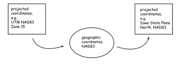
When we have data in one spatial reference (either a GCS or PCS) and we need to convert it to another, we refer to this as "projecting" the data.
If the datums are the same in both the spatial references, then we can just project the data to geographic coordinates (GCS) and then project them to the new projection.
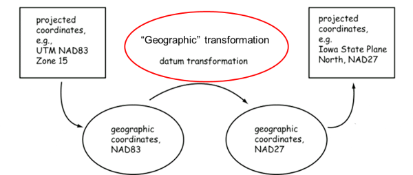
If the datums are different, however, we need to add another step to change the data from one datum to another. This is called a "Geographic transform" or "datum transformation".
When you "Project" data in ArcMap, a green dot will appear next to the "Geographic Transformation" popup box. This box should really be called Datum Transforms because that is all it contains and there are many more geographic transformations (including projecting). Sometimes, ArcMap will select a transformation for you which is OK if you are not worried about a few meters of error (I have seen up to 16 meters). Otherwise, you'll need to scroll through this list to find the transformation that is appropriate for your data. If there is more than one, you can use the HSU Data Hub to select the best transform for your area.
Note: Esri used to have a page containing the areas for each Datum Transformation but the link is no longer valid, extra credit for someone who finds it!
For transforming data from one North American Datum (NAD27, NAD83), to another, you can use a single "NADCON" transformation. For most other transforms, we need to transform the data to WGS84 and then transform it to the new datum.
For selecting datum transformations for tools other than ArcMap (like FWTools), you can use the EPSG database. An easy way to access the EPSG data base is using the HSU Data Hub.
© Copyright 2018 HSU - All rights reserved.